


beledone J3

CASSISFRAMBOISE
User
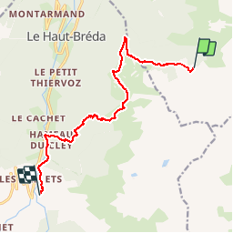

Length
12.2 km

Max alt
1990 m

Uphill gradient
662 m
Km-Effort
23 km

Min alt
997 m

Downhill gradient
1382 m
Boucle
No
Creation date :
2019-09-03 06:22:08.071
Updated on :
2019-09-06 12:14:01.143
7h10
Difficulty : Very difficult

FREE GPS app for hiking
 SityTrail
IGN / Geographical institutes
SityTrail Plus
The world is yours!
About
Trail Walking of 12.2 km to be discovered at Auvergne-Rhône-Alpes, Isère, Le Haut-Bréda. This trail is proposed by CASSISFRAMBOISE.
Positioning
Country:
France
Region :
Auvergne-Rhône-Alpes
Department/Province :
Isère
Municipality :
Le Haut-Bréda
Location:
Pinsot
Start:(Dec)
Start:(UTM)
275449 ; 5021913 (32T) N.
Comments